Ancestry.com's map collection contains several large databases. In this article I examine one of them, the U.S. Map Collection, 1513-1990.
Source Information
Genealogists specify sources so that others can verify their information. This made it really frustrating when Ancestry.com's source information seemed designed to prevent someone from finding the original records. NARA series numbers were always left out. NARA titles were always reworded. Web addresses were never specified for data downloaded from free online sources.
I don't know if they really did try and make it difficult to find the original sources for their information, but I've noticed that lately they have really been doing a good job specifying source information. Unfortunately, the U.S. Map Collection, 1513-1990 must have been done in the ol', careless days. The source information says that the original data came from, "See source or bibliographical info attached to each map." Then, when one views the source or bibliographical information attached to an individual map it states, "See source or bibliographical info attached to each map."
When I came across a map that I had previously downloaded from the Library of Congress (LOC), I wondered if Ancestry.com had obtained some of this map collection from the public domain maps on the LOC website. I tried looking on the LOC site for about a half-dozen maps from this collection and found all of them on the LOC site.
Frankly, it doesn't bother me to have Ancestry.com gather up all the public domain stuff on the Internet and incorporate it into their website. I love the convenience. If they are trying to hide the true source, which I don't know is the case, that would bother me.
Illegible Resolution
What does bother me in this case is they seem to have copied these maps from the Library of Congress and then dumbed them down to a lower resolution. Unfortunately, the lower resolution makes the maps illegible.
Take for example, "A map of Lewis and Clark's track..." Click one of the links below to see the map on Ancestry.com:
- Lewis & Clark's Journey (FREE) - Use this link if you don't have a subscription.
- A map of Lewis and Clark's track... - If you have a subscription, use this link to see the biographical information about the map.
- A map of Lewis and Clark's track... - If you are at a public library with the Ancestry Library Edition distributed by ProQuest, try this link.
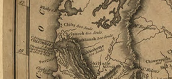
Zoom in as close as possible on the mouth of the Columbia River. Notice that little, if any, of the small text can be deciphered.

Detail from an Ancestry.com copy of an LOC map.
Note the text is illegible.
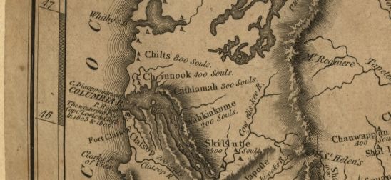
Compare it to the same map at LOC website. Zoom in to a level comparable to the maximum Ancestry.com level. Notice that most, if not all, of the small text is legible. Also note that you can zoom in even one step further!

Detail from the original LOC map.
Note that all the text is legible.
The moral? If you find an illegible map that you need in the U.S. Map Collection, 1513-1990, search for it at the Library of Congress and you may find a legible copy of the map.
This brings up a question about Ancestry resolution that I had been wondering about recently. Just observed that I could barely read some documents that I had posted to my AncestryMemberTree last year as "Photos" with a "Document/Certificate" type.
ReplyDeleteHas Ancestry changed something recently with regard to the resolution used to display these "Photos"?
[Whenever readability for a "Photo/Document" was a problem after posting last year, I would repost as a PDF "Story" to permit magnification so I must have been able to at least somewhat clearly read these now barely legible items last year at the time of posting.]
Was questioning if my eyesight was declining (computer/monitor hasn't changed) -- but now your blogpost is causing me to wonder if Ancestry has made a general change in the meanwhile with regard to the resolution delivered for images from their site?
Insider,
ReplyDeleteAs you now an ex-employee and thus presumably "just" a normal customer/subscriber, other than offering other users a way to find a better resolution version of the same map, do you as a customer now inform Ancestry of this problem and expect them to fix it, i.e. provide a better quality scan?
Mike
Like "Tyler" stated, I too thought it was me and my eyesight. Thanks for bringing this subject up.
ReplyDelete